
By Mike Scott
If you look at a map of New Orleans, Central City seems aptly named enough. There it is, right smack dab in the center of the Mississippi River’s famed crescent.

Geography aside, Central City — in recent decades defined by its crime rate — is a neighborhood that lies at the heart of New Orleans’ history and culture. As with much else in New Orleans, however, it is often in conflict with itself.
From the start in the 1820s of settlement of the neighborhood — carved largely out of former riverfront plantations lining what was once charmingly referred to as “the Tchoupitoulas Coast” — Central City was a place of working-class optimism, a place where newly arrived immigrants found a home. Decades later, it would become a place of crushing poverty.
It was at one time the home of such celebrated jazz pioneers as Buddy Bolden and Kid Ory. It would also later be the home of Howard Johnson’s sniper Mark Essex.
It is filled with architectural gems — which are outnumbered only by crumbling ruins.
It is a place of many firsts, such as the construction in 1884 of the first of the city’s network of “moon towers,” designed to light whole neighborhoods at once with newfangled electricity. It also saw the construction of the Magnolia public housing complex, the first such project in the nation to receive federal funding under the housing component of President Franklin Delano Roosevelt’s New Deal.
It was where Martin Luther King Jr.’s Southern Christian Leadership Conference was founded in 1957, an effort to bring white and black people together. It was also where Robert Charles shot a white police officer, sparking the notorious New Orleans race riots of 1900, tearing the city apart.
The list goes on, but Central City today — a blade-shaped triangle hemmed in on the city’s official neighborhood map by the Central Business District to the east, the Garden District to the south, and the Milan, Touro and Broadmoor neighborhoods to the west — is regardless often overlooked. And forsaken.
Those who write it off, though, are writing off a storied swath of a storied city.
•••
It all started with a train. Specifically, it started with the New Orleans and Carrollton Railroad, which, when it began running on Sept. 26, 1835, became one of the first public trolley systems in the United States.

As that name suggests, the rail line linked New Orleans with the resort town of Carrollton, a small outpost located 5.2 miles upriver in what was then Jefferson Parish.
Admittedly, that doesn’t sound particularly far. But in 1835, those 5.2 miles covered farmland, swampland and a whole lot of nothing else. Even with the train — which ran from present-day Poydras Street to today’s Carrollton Avenue on tracks now occupied by those for the St. Charles Avenue streetcar — the trip took more than an hour, chugging along at a steady but snail-like 4-mph pace (the same pace as a brisk walk).
Riders on that train first passed through the city of Lafayette, now known as Faubourg Lafayette, and which had been carved out of old plantation property in the 1820s to become the first parish seat of Jefferson Parish.
Next, it passed through remnants of the old Livaudais Plantation property, followed by the former Delassize property, which was once home to a bustling sawmill, and then on to Carrollton.
But even slow trains have a way of sparking development. So, it wasn’t soon after the New Orleans and Carrollton Railroad began running that landowners along the route began subdividing and selling off their property. That property was quickly filled by newly arrived immigrants moving to the fast-expanding city as part of the population boom following the Louisiana Purchase in 1803.
The Livaudais property became Faubourg Livaudais. The Delassize property became Faubourg Delassize. With Faubourg Lafayette (which was annexed by New Orleans in 1852), they make up roughly the southernmost third of today’s Central City.
Around the same time the New Orleans and Carrollton Railroad began running, digging had started on the New Basin Canal, which — running along the present-day site of the Pontchartrain Expressway — provided a direct maritime link between downtown New Orleans and Lake Pontchartrain.
Many of the immigrant hands that dug it settled in these new faubourgs, first Irish and Germans, followed later by Italians and Jews, as well as black residents moving into the city from more rural areas in the years after the Civil War.
Most of the homes the city’s newest residents lived in were humble ones, befitting the area’s working-class roots and standing in stark contrast to the finer homes, clustered closer to St. Charles Avenue, that belonged to the men who owned and rented out the neighborhood’s preponderance of smaller shotgun houses. But it was a lively little neighborhood, filled with shops of all description.
Growing fairly quickly, it pushed northward and eventually included the area known today as Hoffman Triangle, which gives Central City its angular profile.
•••
All these years later, a multitude of ghosts of Central City’s rich, multi-ethnic past are plentiful for those inclined to look for them.
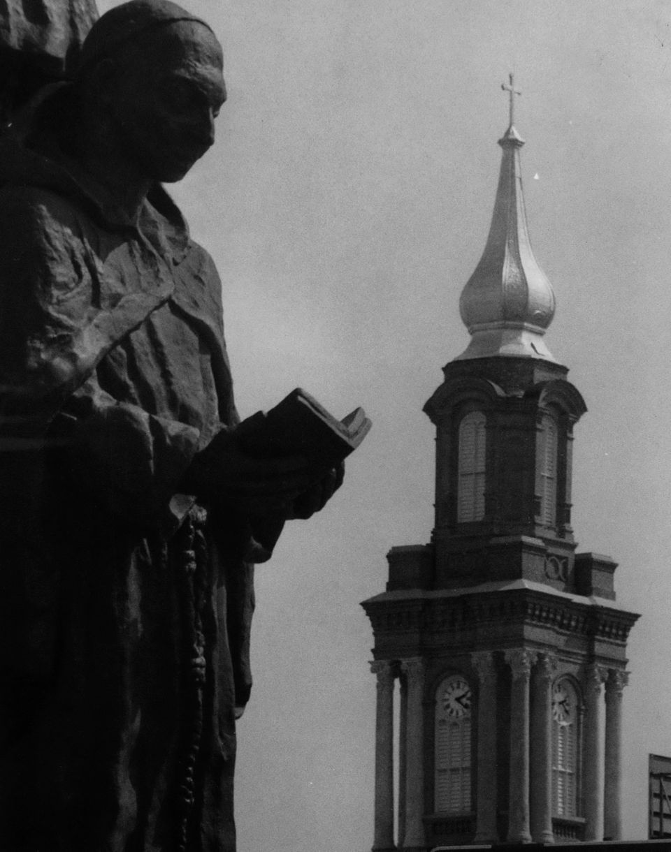
St. John the Baptist Catholic Church, for example, with its distinctive golden steeple standing along the elevated expressway carrying motorists to the West Bank, was built largely for the neighborhood’s Irish residents. A school that was built along with it was demolished to make room for that elevated thoroughfare, part of the Pontchartrain Expressway.
The Leidenheimer Bakery, which was founded in 1896 on Dryades Street by German immigrant George Leidenheimer — and later moved a few blocks away to Simon Bolivar Avenue — still daily cranks out one of the city’s most cherished culinary products: the po-boy loaf.
Jazz pioneer Buddy Bolden grew up at 2309 First Street. Trombonist Kid Ory lived at 2135 Jackson Ave. On Lasalle Street, the historic Dew Drop Inn, a hub for black musicians visiting the city during the Jim Crow era — and, thus, also the site of countless late-night musical performances that would influence a generation of musicians — added to the neighborhood’s cachet as an incubator of New Orleans music.
Other notable New Orleans musicians from Central City include Professor Longhair and hip-hop mogul Master P.
The Congregation Anshe Sfard synagogue, built in 1925, exists as a reminder of what was the neighborhood’s thriving Jewish population.
And business owners of all shades and backgrounds operated the scores of shops that lined the bustling Dryades Street, which — also boasting the city-run Dryades Market at Dryades and present-day Martin Luther King Jr. Boulevard — was the neighborhood’s central commercial thoroughfare throughout the late 18th century and well into the 20th century.
Central City, once just empty land, had become one big demographic melting pot.
That, however, was about to change.
•••
Oretha Haley noticed something. She couldn’t help but notice.
By the mid-20th century, most of Central City’s white families had moved out, leaving behind a predominately black neighborhood. But Dryades Street, long the neighborhood’s main commercial drag, was dominated by white-owned businesses.
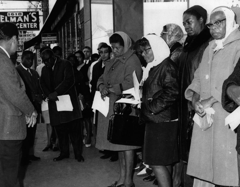
The owners of many of those businesses, while happy to take the money of black residents, refused to hire them.
That, Castle decided in 1960, was not right. So, she organized a boycott of Dryades Street merchants. To make sure the message was heard, she also helped organize a student sit-in at McCrory’s five-and-dime in the white-dominated Canal Street shopping district.
The gambit was successful on two fronts: It prompted Dryades Street merchants to change their ways, and it also launched Castle into a career that — in addition to seeing her clapped in irons more than a dozen times, by her estimate — would establish her as one of the city’s most prominent civil rights activists.
In 1989, an 11-block stretch of Dryades — from Calliope Street to Phillip Street — was named Oretha Castle Haley Boulevard.
She wasn’t alone. Elsewhere in Central City, the Rev. A.L. Davis was leading the fight from the pulpit at New Zion Baptist Church on Third Street. It was during a meeting there with the Rev. Martin Luther King Jr. and others that the civil rights group the Southern Christian Leadership Conference was born.
Today, A.L. Davis Park on Lasalle Street is a key meeting place for Mardi Gras Indians as they embark on their annual Super Sunday processions.
But by the late 1960s, Central City began a slow, painful descent into crime and violence.
With integration, black consumers could do their shopping wherever they wanted — including on the fancier, more fashionable Canal Street. Dryades Street merchants suffered as a result.
The onset of the mall era in America — including the opening of Metairie’s Lakeside Shopping Center in 1960 and New Orleans East’s Lake Forest Plaza in 1973 — only worsened the neighborhood’s economic woes.
Things bottomed out in the 1980s as the crack cocaine epidemic took hold across America, sinking its hooks most deeply into the type of blighted, economically challenged neighborhoods that Central City had become. If it wasn’t the murder capital of New Orleans, it was close — which put it in the running for the title of murder capital of the world.
But as might be expected of a neighborhood at the center of one of the world’s most resilient cities, there are signs that Central City is bouncing back.
Anchored by such tenants as Cafe Reconcile, the Southern Food & Beverage Museum, Casa Borrega, the Ashe Cultural Arts Center and a new, 21st century version of the Dryades Public Market, Oretha Castle Haley Boulevard is enjoying a notable revitalization.
In June 2017, the National Main Street Center decorated O.C. Haley with its Great American Main Street Award. There’s hope among business people and residents of Central City that momentum can be maintained — and it’s hard not to hope along with them.
Central City might be heartbroken after years of blight, crime and violence, but make no mistake: It remains the heart of New Orleans. And the heart of New Orleans is still beating.
This story was originally published in June 2018 by NOLA.com | The Times-Picayune.
